Dry Surveying Instruments

| Cave Formation | |||
| Training & Safety | |||
| Equipment | |||
| Projects | |||
| Papers | |||
| Photos | |||
| Video | |||
| Links | |||
| Contact Us | |||
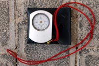 |
Compass: measures horizontal angles. Measurements are given in degrees and quadrants; the readings are azimuths and bearings, respectively. |
||
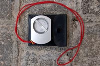 |
Clinometer: measures vertical angles. | ||
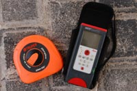 |
Graduated Tape or Rangefinder: measures distances | ||
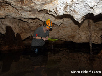
| A survey must be conducted in order to obtain the information to create the map of a cave. During the survey, the distance and angles between chosen stations are measured and recorded. Sketches of, and notes about, the cave should also be made. The more information collected, the more detailed the cartographer can make the map. | |||
| Cave surveying technique isn’t difficult to understand, but familiarizing oneself with the instruments takes a little time. It also takes some while to become comfortable with the team system; we often find the first quarter of the cave survey to be quite slow, but we once we have established our “rhythm” the remainder of the survey moves rapidly. | |||
| Before attempting a cave survey, one should have plenty of survey practice. Living rooms and backyards are great places to improve one’s technique. After one is comfortable with the how-tos, survey practice should continue in a small tourist cave (or the cavern zone or a small room in a tourist cave). One should always endeavor to have as little impact on a cave as possible. | |||
The best instructors on surveying (both wet and dry) tend to be those familiar with detailed cartography, as they know what information will be the most useful for creating a map. The book On Station, by George R. Dasher covers all aspects of cave surveying and mapping and is an excellent addition to any caver’s library. |
|||
